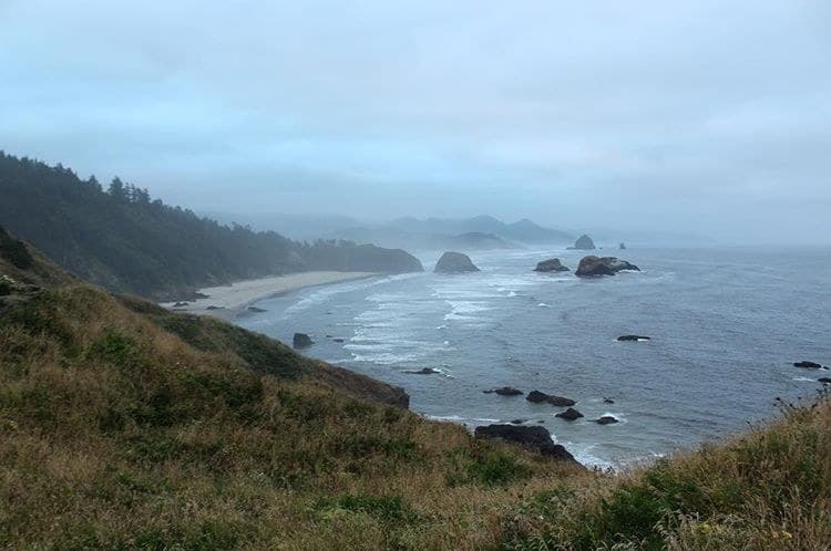
The Oregon Coast Trail runs about 362 miles along the Oregon coastline through dozens of state parks. Hiker/biker camps along the way are first-come, first-served with no reservation; this page gives sourced trip info and links to each park's own booking page for a reserved site.
“362 miles of Oregon coastline, linked by a string of state park hiker/biker camps.”
Plan your Oregon Coast State Parks (OR) trip here, then get your permit from the agency.
Walk-up permit
How to get Oregon Coast Trail
Hiker/biker camps along the route are first-come, first-served; nothing to scan. A reserved (non-hiker/biker) site can be booked directly with the relevant Oregon State Park.
Official permit pagePlanning another trip? See the permits we alert on.
Oregon Coast Trail permit season
- route distance, point to point
- 362mi
Oregon Coast Trail elevation profile
Columbia River / Fort Stevens (northern terminus) to California border (southern terminus)Columbia River / Fort Stevens (northern terminus)
Section 1 begins here at the Columbia River.
- Mile
- 0
- Elevation
- ≈8 ft
Oregon Coast Trail landmarks
How to get an Oregon Coast Trail permit
No reservation. You get the permit when you arrive.
Arrive in person
Get your permit
Hiker/biker camps along the route are first-come, first-served; nothing to scan. A reserved (non-hiker/biker) site can be booked directly with the relevant Oregon State Park.
Head out
Oregon Coast State Parks (OR) trailheads
- Fort Stevens (Columbia River)
- California border
The two Oregon Coast State Parks (OR) trailheads in full
Primary
Fort Stevens (Columbia River)- California border
As of September 2026, Oregon Coast Trail in Oregon Coast State Parks (OR), Oregon requires a permit issued via walk-up. Oregon Coast Trail rates 3/10 on PermitSnag's demand index. The Oregon Coast Trail route covers 362 miles.
- Type
- Thru-Hike
- Location
- Oregon Coast, Columbia River to California border, OR
How this permit is issued
Official permit page →Step 1: How this permit is issued
Hiker/biker camps along the route are first-come, first-served; nothing to scan. A reserved (non-hiker/biker) site can be booked directly with the relevant Oregon State Park.
Step 2: Check the agency page before you go
Fees, hours and closures change. Confirm the current process at Oregon State Parks before your trip.
Step 3: Have backup plans
Office hours move, ground closes, and popular trailheads get busy. Know an alternative route or date before you drive out.
More on Oregon Coast Trail: Live availability activityOregon Coast Trail permit itinerary
The Oregon Coast Trail hike
- Distance
- 362 miles
- Route Type
- Point to Point
- Duration
- varies by section, 2-10 days per section; a full thru-hike takes several weeks
362 miles of Oregon coastline, linked by a string of state park hiker/biker camps.
About this permit
The Oregon Coast Trail runs the length of the Oregon coastline through dozens of state parks. Hiker/biker camps along the way are first-come, first-served with no reservation.
The route
From Fort Stevens at the Columbia River, the trail runs south through hiker/biker camps at Devil's Lake, Cape Lookout, Nehalem Bay, Beverly Beach, Honeyman, Bullards Beach, Sunset Bay, Cape Blanco, and Harris Beach, ending at the California state line.
The feeling
The route runs from the mouth of the Columbia River at Fort Stevens down through dune country at Honeyman State Park to the California border, with a first-come hiker/biker camp at nearly every state park along the way.
How hard the Oregon Coast Trail hike is
- Physical DemandFitness and endurance required5/5
- Technical SkillClimbing, scrambling, or specialized skills1/5
- NavigationRoute finding and trail clarity1/5
- CommitmentDifficulty of bailing out mid-route4/5
Best for: Experienced hikers with excellent fitness and relevant technical skills.
Recommended experience: Should have completed 10+ mile day hikes with significant elevation gain.
When to hike Oregon Coast Trail
Weather Forecast
Trailhead (5,000 ft)
Backcountry Tips
- Day 4: 66% chance of precipitation. Pack rain gear.
Today
62°
47°
Sun
64°
52°
Mon
60°
49°
Tue
58°
54°
66%
Wed
62°
50°
Thu
68°
52°
Fri
60°
53°
Oregon Coast Trail photography guide
Classic Shots
- The Columbia River mouth at Fort Stevens
- The dunes near Honeyman State Park
Oregon Coast Trail rules, gear and safety
Safety & planning
Emergency Info
Emergency contacts, ranger station locations, and satellite communicator tips for Oregon Coast Trail.
Food Storage
Bear canister requirements, approved container lists, and rental locations for this permit.
Gear Checklist: Required and recommended gear for Oregon Coast Trail · Shuttle Services: Trailhead transportation options · Guide Services: Experienced wilderness guides
Some links may be affiliate links. Purchases support PermitSnag at no extra cost to you.
Oregon Coast Trail FAQ
Do I need a permit to hike the Oregon Coast Trail?
No. There is no permit or reservation required for the trail or its hiker/biker campsites.
How long is the Oregon Coast Trail?
About 362 miles according to Oregon State Parks, running the length of the Oregon coast from the Columbia River to the California border.
Are hiker/biker campsites reservable on the Oregon Coast Trail?
No. They're first-come, first-served at nearly every state park on the coast.
Can I hike the whole Oregon Coast Trail on the beach?
Most of it, but not all. Some stretches require walking on the shoulder of US 101 or other roads, and some sections are passable only at low tide.
Is the Oregon Coast Trail one continuous trail?
Not entirely. About 10 percent of it runs through disconnected gap sections that require road walking to link up.
Are there rules to protect nesting birds on the Oregon Coast Trail?
Yes. From March 15 to September 15, hikers on protected nesting beaches must walk on wet sand rather than the dry upper beach.
Oregon Coast Trail trail conditions and trip reports
Trail Conditions
No active conditions reported
Sign in to report trail conditions.
Questions
No questions yet
Be the first to ask about Oregon Coast Trail.
Trip Reports
Write ReportNo trip reports yet
Be the first to share your experience at Oregon Coast Trail.
Write the First ReportAlternatives to an Oregon Coast Trail permit
Where to stay near Oregon Coast Trail
Plan the full trip, not just the permit
Build your full itinerary start to finish
Add your dates and get a day-by-day plan: what needs a permit, what gear to bring, and one link to share with your whole group to coordinate every step.
No permit needed to start
One tick helps us more than you’d think
Google lets you pick the sites it highlights for you. Add PermitSnag and our permit pages get marked as one of yours in AI Overviews and AI Mode.
Takes less than a minute.