Chippewa Flowage Boat-In Campsites Permit
Chippewa Flowage (WI) · Wisconsin
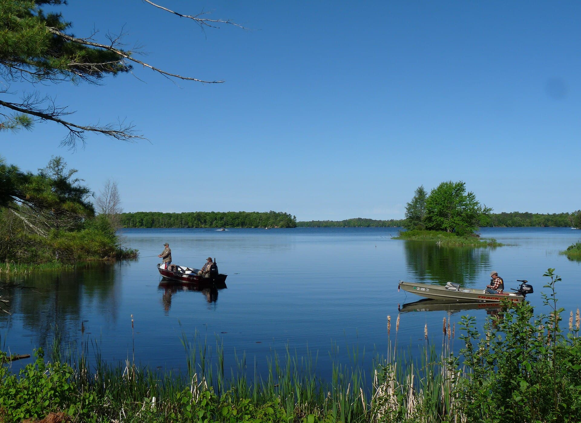
Eleven primitive boat-in sites scattered around the flowage. Booked under the Wisconsin DNR "Boat-in" category.
70% of the openings our scanner caught on Chippewa Flowage were gone within 5 minutes.
Plan the full trip, not just the permit
Build your full itinerary start to finish
Add your dates and get a day-by-day plan: what needs a permit, what gear to bring, and one link to share with your whole group to coordinate every step.
No permit needed to start
Chippewa Flowage Quick Facts
Chippewa Flowage Permit Facts
- As of September 2026, Chippewa Flowage in Chippewa Flowage (WI), Wisconsin requires a permit issued via reservation.
- Chippewa Flowage is a high-demand permit, rating 8/10 on PermitSnag's demand index.
- Cancelled Chippewa Flowage permits are re-released on the booking system; PermitSnag monitors availability and alerts watchers when dates open.
Key Information
Permit Details
What to Expect
Highlights
- •DNR: "There are 11 primitive island campsites on DNR islands. One DNR campsite, Cedar Tops West, has been improved with accessible facilities."
- •"All campsites are accessible by water only, and due to their remoteness, it is recommended that campers leave an itinerary with friends or relatives."
- •"Each campsite is marked with a sign and has a fire ring, picnic table and open-air box latrine." DNR names no water at the sites.
- •The launch to use: "Campers are encouraged to use the Cty. Hwy. CC South Boat Landing for boat access, overnight parking, potable water and trash services. Trash services are not offered at the other DNR boat landings."
- •This changed recently. DNR: "Beginning in 2025, the 11 DNR island campsites in the Chippewa Flowage will require reservations and a camping fee to camp at these sites."
- •For 2026, every Lac Courte Oreilles tribally-owned campsite is closed to the public for campsite rehabilitation and island restoration.
Best Time to Visit
The reservation season is May 1 through November 30, and DNR will not guarantee access outside it. For 2026, the Lac Courte Oreilles tribal sites are closed to the public entirely, so the 11 DNR island sites are the whole public inventory.
Hazards & Considerations
- !Bears, on islands. DNR, on this property's camping page: "Bears can be present at this property." Its statewide guidance adds: "Bears are excellent swimmers who may travel to island sites searching for food. Coolers, blue 'bear barrels,' cookware and even vehicles are not bear resistant."
- !Remoteness — DNR recommends leaving an itinerary with friends or family precisely because help is not close.
- !Open water on Wisconsin's third-largest lake, with 233 miles of irregular shoreline to get turned around on.
- !No water on the islands; the nearest potable supply is the CC South landing.
How to Get This Permit
Create a Wisconsin DNR (GoingToCamp) account
Sign up at Wisconsin DNR (GoingToCamp) if you don't have an account. Have your payment info ready.
Know the release schedule
Permits typically release on a rolling basis. Check the specific release time for your desired dates.
Be ready when permits drop
Log in a few minutes early. Have your dates, group size, and payment ready to go.
Monitor for cancellations
If your dates are sold out, people cancel all the time. Set up PermitSnag alerts to catch openings instantly.
About This Permit
Wisconsin DNR: "The Chippewa Flowage, a 15,300-acre impoundment, is located in central Sawyer County, 15 miles east of Hayward. Dotted with about 200 undeveloped islands, it is Wisconsin's third-largest lake and boasts a highly irregular, wooded and generally undeveloped 233-mile shoreline. Boat-in to camp at one of several primitive campsites or explore the seemingly endless maze of islands, points, bays, floating bogs and channels." (dnr.wisconsin.gov/topic/Lands/ChippewaFlow, read 2026-08-09.)
The Experience
Why It Matters
The "Big Chip" was filled in 1923 to hold water for downstream power and flood control, and what it left is a 15,300-acre lake with about 200 undeveloped islands and a 233-mile shoreline that is still mostly wooded. DNR: "The flowage offers a fishing experience generally found only on lakes farther north in Minnesota or Canada." Until 2025 the island sites were free and first-come; they now take reservations, which is why they can be watched at all.
The Feeling
You pick an island. DNR's own description of what is out there: "the seemingly endless maze of islands, points, bays, floating bogs and channels." A sign, a fire ring, a picnic table and a box latrine is the whole camp, and the nearest tap is back at the landing.
Trailhead Information
County Highway CC South Boat Landing
The launch DNR recommends for campers, in the central part of the property.
Before you rely on this water
DNR names potable water at this landing and at no other. Wisconsin water systems are weather-dependent and may be off from roughly Oct. 1 through May 15, which overlaps the tail of the May 1 - Nov. 30 camping season.
Parking
Overnight parking, and the only DNR landing on the flowage with trash services. No vehicle admission sticker is required.
Getting There
Off County Highway CC in the central portion of the property; reached from the south via State Highways 27 and 70, or from the north via County Highway B.
Nearest Services
Hayward, 15 miles west.
Rules & Regulations
- •"DNR campsites on the Chippewa Flowage must be reserved for camping from May 1 through November 30. Outside the reservation season the department cannot guarantee campsite access or availability."
- •Reservations run up to 11 months ahead, and you must reserve before setting up on any site.
- •"Camping is allowed only at designated, signed island campsites. No new campsites may be established."
- •"Sites must be occupied the same day that they are set up."
- •"The camper's maximum stay is 10 days."
- •"Chainsaws, generators and fireworks are prohibited."
- •"All plastic, cans, glass and trash must be carried out and disposed of properly when leaving. Do not place in pit toilets. Trash receptacles are provided at public landings."
- •"Burn only paper products and wood in fire pits and extinguish fires completely using water or clean soil."
- •"Do not cut, carve or deface trees, tables or benches, or drive nails into trees. Please do not hang lanterns from trees."
- •Firewood must come from within 10 miles and never from outside Wisconsin; removing driftwood from the property is prohibited by state law.
- •No vehicle admission sticker is required at the Chippewa Flowage.
Gear Checklist
Required
- A boat — every site is water-access only
- All drinking water; DNR names potable water at the CC South landing and none on the islands
- Rubbish bags: everything comes back to a landing
- A float plan left with someone, which DNR recommends outright
Recommended
- A bear-resistant food container or a hang kit — DNR: "Bears are excellent swimmers who may travel to island sites searching for food"
- A chart of the flowage; DNR describes "the seemingly endless maze of islands, points, bays, floating bogs and channels"
- Wind-capable paddling gear for a 15,300-acre lake
Plan Your Trip
Gear Checklist
Required and recommended gear for Chippewa Flowage
Shuttle Services
Trailhead transportation options
Browse all shuttlesGuide Services
Experienced wilderness guides
Browse all guidesSome links may be affiliate links. Purchases support PermitSnag at no extra cost to you.
Key Landmarks
Cedar Tops West
The one DNR island campsite improved with accessible facilities.
County Highway CC South Boat Landing
The launch DNR recommends: boat access, overnight parking, potable water and the only landing with trash services.
mino-giizhigad Trail
A newer hiking trail on DNR land east of the CC North landing, through backland forest with views over the flowage.
The islands
About 200 of them, undeveloped, scattered across 15,300 acres — DNR's count, not an estimate.
Chippewa Flowage FAQ
How do I get a Chippewa Flowage permit?
Chippewa Flowage permits use a reservation system. PermitSnag sends lottery open, deadline, and results reminders; you can also enable cancellation alerts if spots open later.
When is the best time to visit Chippewa Flowage?
Check with the managing agency for current season dates. Weekdays generally have better availability than weekends.
How competitive is the Chippewa Flowage permit?
This permit has a demand score of 8/10, making it highly competitive. We recommend having backup dates and using PermitSnag's cancellation alerts.
What if I can't get a Chippewa Flowage permit?
Cancellations happen daily. Set up alerts with PermitSnag to get notified the moment a spot opens up. Pro and $19 single-permit alerts are checked about every minute, 24/7; free accounts are checked hourly.
👥Community
Trail Conditions
No active conditions reported
Sign in to report trail conditions.
Questions
No questions yet
Be the first to ask about Chippewa Flowage.
Trip Reports
Write ReportCan't Get a Chippewa Flowage Permit?
Consider these alternatives if your preferred dates aren't available.
Chippewa Moraine Backcountry Sites
Same AreaThree outpost sites an hour south on the Ice Age Trail, one of them canoe-in.
Tradeoffs
Two are a half-mile walk, so a boat becomes optional — but there are only three sites.
Rock Island Backpack Campsites
Similar ExperienceIsland camping in Lake Michigan instead, with a ferry doing the crossing for you.
Tradeoffs
No boat needed and drinking water on the island, but the ferry timetable is the whole season.
Where to Stay
Nearby campgrounds to complete your Chippewa Flowage trip
A small favor
One tick helps us more than you’d think
Google lets you pick the sites it highlights for you. Add PermitSnag and our permit pages get marked as one of yours in AI Overviews and AI Mode.
Takes less than a minute.