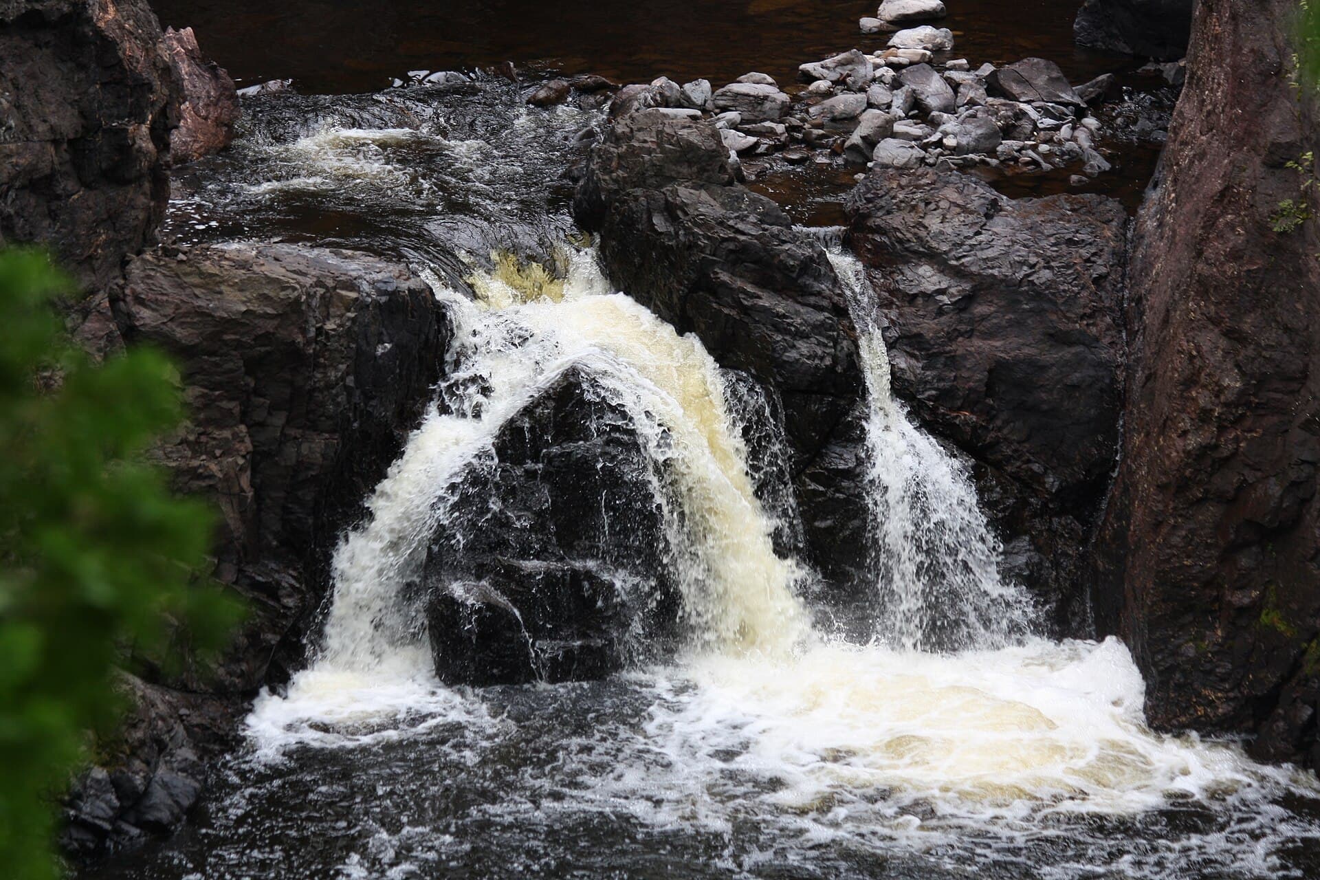
Copper Falls Backpack Campsite Permit
Copper Falls State Park (WI) · Wisconsin
One backpack site. A single site means the facility is either open or gone — there is no second chance on a given night.
70% of the openings our scanner caught on Copper Falls were gone within 5 minutes.
Plan the full trip, not just the permit
Build your full itinerary start to finish
Add your dates and get a day-by-day plan: what needs a permit, what gear to bring, and one link to share with your whole group to coordinate every step.
No permit needed to start
Copper Falls Quick Facts
Copper Falls Permit Facts
- As of September 2026, Copper Falls in Copper Falls State Park (WI), Wisconsin requires a permit issued via reservation.
- Copper Falls is a high-demand permit, rating 8/10 on PermitSnag's demand index.
- The Copper Falls route covers 2 miles.
- Cancelled Copper Falls permits are re-released on the booking system; PermitSnag monitors availability and alerts watchers when dates open.
Key Information
Permit Details
What to Expect
Route Details
Highlights
- •There is exactly one backpack campsite at Copper Falls, and it is reservation-only. If it is taken, there is no second option in the park.
- •DNR puts it "on the banks of the Bad River overlooking the sandstone ledges, about a 2-mile hike from the parking lot."
- •"This site is very primitive and contains only a stone-lined fire ring."
- •There is a primitive latrine nearby. DNR: "campers should plan to bring their own toiletries and sanitizer."
- •"There is no water available, and campers should plan accordingly."
- •The site sits on the North Country National Scenic Trail, which runs more than four miles through the park.
Best Time to Visit
The park is open year-round, 6 a.m. to 11 p.m., and the site is bookable through it. Park water and showers run Memorial Day weekend to Oct. 1, depending on the weather, so outside that window everything you drink comes off your back. Winter closes part of the Doughboys Trail for ice.
Hazards & Considerations
- !No cell coverage. DNR: "This is a remote site, and cell service may be limited or non-existent. Please follow backcountry best practices and inform a friend or family member where you will be, how long you will be gone and when you plan on returning."
- !No water at the site at all — this is the one that catches people out on a two-mile walk in summer.
- !Icy rock stairs in winter: DNR closes a portion of the Doughboys Trail because "ice and snow make the rock stairs very slippery."
- !Wisconsin state park water systems are weather-dependent; showers and drinking water at Copper Falls run only from Memorial Day weekend to Oct. 1.
How to Get This Permit
Create a Wisconsin DNR (GoingToCamp) account
Sign up at Wisconsin DNR (GoingToCamp) if you don't have an account. Have your payment info ready.
Know the release schedule
Permits typically release on a rolling basis. Check the specific release time for your desired dates.
Be ready when permits drop
Log in a few minutes early. Have your dates, group size, and payment ready to go.
Monitor for cancellations
If your dates are sold out, people cancel all the time. Set up PermitSnag alerts to catch openings instantly.
Difficulty Assessment
Fitness and endurance required
Climbing, scrambling, or specialized skills
Route finding and trail clarity
Difficulty of bailing out mid-route
Best For
Hikers of moderate fitness willing to put in the effort.
Recommended Experience
Basic hiking experience. Start with shorter trails if new to hiking.
About This Permit
Wisconsin DNR: "Ancient lava flows, deep gorges and spectacular waterfalls make Copper Falls State Park one of Wisconsin's most scenic parks. Log buildings built by the Civilian Conservation Corps in the 1930s add to the park's charm. The park offers camping, hiking, bicycling, picnicking, fishing and swimming opportunities in Loon Lake. The 1.7-mile Doughboy's Nature Trail, along the Bad River, is one of the best hikes in Wisconsin." (dnr.wisconsin.gov/topic/parks/copperfalls, read 2026-08-09.)
The Experience
Why It Matters
A single campsite means the booking behaves differently from everything else in the Wisconsin system: there is no partial availability. Any night it is taken, the facility is sold out. It also sits on the North Country National Scenic Trail, a footpath DNR describes as running "from Vermont to North Dakota" — so this is a thru-hiker's night as much as a weekender's.
The Route
Park in the small lot off the maintenance/disabled access road, before the road turns to gravel — there is a post marking it, and DNR is explicit that backpack campers may not use the main picnic-area lot. From there the walk is about two miles: down the gravel road, then following the brown signs to the site. It finishes on the bank of the Bad River, above the sandstone ledges. Carry your water; the site has none.
The Feeling
Copper Falls is a gorge park: ancient lava flows, water cutting down through them, and CCC log buildings from the 1930s at the top. The campsite is far enough down the trail that the day-use noise is gone, and DNR is blunt that your phone will not work.
Trailhead Information
Backpack site parking (maintenance/disabled access road)
A small lot off the maintenance/disabled access road, marked with a post. The two-mile walk to the site starts here.
Parking
DNR: "Backpack campers must park here, not in the main picnic area." The lot is before the point where the road turns to gravel.
Nearest Services
Mellen, about two miles southwest. Firewood is sold at the woodshed near the park entrance.
Rules & Regulations
- •Backpack parking is off the maintenance/disabled access road, not the main picnic area. DNR: "Before the road turns to gravel, there is a small lot with a post identifying where to park for the site."
- •Pets are not permitted on the Doughboys Trail, so a dog means taking the campsite's signed route instead and skipping the falls.
- •Firewood must be certified or come from within 10 miles; the park sells it at the woodshed near the entrance.
- •Reservations run up to 11 months ahead; backpack sites may be booked for a single night.
- •Check-in is 3 p.m., checkout is 1 p.m.
- •No more than 14 days of camping in any 21 days.
- •The park is closed to non-campers between 11 p.m. and 6 a.m.
- •Fires in the fire ring only; carry out everything you carry in.
- •Pets on a physical leash no longer than 8 feet, and never left unattended — including in a vehicle or at a campsite.
- •A vehicle admission sticker is required.
Gear Checklist
Required
- All your water for the stay, plus a means to treat river water if you plan on more — DNR states there is none at the site
- Toiletries and hand sanitizer for a primitive latrine
- A stove; the site has a fire ring and nothing else
- A way to navigate without a signal
Recommended
- Paper map or an offline track — DNR flags limited-to-no cell service
- Microspikes if you are walking the gorge trails in winter, when DNR closes part of the Doughboys route because the rock stairs ice over
Plan Your Trip
Gear Checklist
Required and recommended gear for Copper Falls
Shuttle Services
Trailhead transportation options
Browse all shuttlesGuide Services
Experienced wilderness guides
Browse all guidesSome links may be affiliate links. Purchases support PermitSnag at no extra cost to you.
Key Landmarks
Copper Falls and Brownstone Falls
The heart of the park, on the 1.7-mile Doughboys Nature Trail. DNR calls it "one of the best hikes in Wisconsin." Pets are not allowed on it.
Tyler Forks Cascades
Crossed by a historic CCC bridge on the 0.5-mile universal trail.
Observation Tower (CCC 692 Trail)
A 1-mile spur to a 65-foot tower. DNR: "Views from atop the tower include Lake Superior, the Apostle Islands and the surrounding Penokee Range."
North Country National Scenic Trail
Passes through the entire length of the park — more than four miles — and the backpack site is on it.
Red Granite Falls
2.5-mile trail in the southern part of the park, from Loon Lake to the falls on the Bad River.
Copper Falls FAQ
How do I get a Copper Falls permit?
Copper Falls permits use a reservation system. PermitSnag sends lottery open, deadline, and results reminders; you can also enable cancellation alerts if spots open later.
When is the best time to visit Copper Falls?
Check with the managing agency for current season dates. Weekdays generally have better availability than weekends.
How competitive is the Copper Falls permit?
This permit has a demand score of 8/10, making it highly competitive. We recommend having backup dates and using PermitSnag's cancellation alerts.
What if I can't get a Copper Falls permit?
Cancellations happen daily. Set up alerts with PermitSnag to get notified the moment a spot opens up. Pro and $19 single-permit alerts are checked about every minute, 24/7; free accounts are checked hourly.
👥Community
Trail Conditions
No active conditions reported
Sign in to report trail conditions.
Questions
No questions yet
Be the first to ask about Copper Falls.
Can't Get a Copper Falls Permit?
Consider these alternatives if your preferred dates aren't available.
Pattison Backpack Camp Area
Same AreaThree sites 1.6 miles in, below Wisconsin's highest waterfall, on the way to Superior.
Tradeoffs
Three sites instead of one, and vault toilets instead of a latrine — but you still carry all your water.
Chippewa Moraine Backcountry Sites
Similar ExperienceThree outpost sites on the Ice Age National Scenic Trail, two of them within half a mile of the interpretive centre.
Tradeoffs
A much shorter walk in, and three chances instead of one on any given night.
Where to Stay
Nearby campgrounds to complete your Copper Falls trip
A small favor
One tick helps us more than you’d think
Google lets you pick the sites it highlights for you. Add PermitSnag and our permit pages get marked as one of yours in AI Overviews and AI Mode.
Takes less than a minute.