Reservation6/10
Buckskin Gulch overnight permit
World's longest slot canyon. The day-use permit is sold as a pass with no daily ...
Paria Canyon-Vermilion Cliffs Wilderness · Arizona
38-mile point-to-point slot canyon traverse from White House Trailhead (Utah) to Lees Ferry (Arizona).
70% of the openings our scanner caught on Paria Canyon were gone within 10 minutes.
Build your full itinerary start to finish
Add your dates and get a day-by-day plan: what needs a permit, what gear to bring, and one link to share with your whole group to coordinate every step.
No permit needed to start
Spring (March-May) and fall (September-November) offer ideal temperatures. Summer brings flash flood risk from monsoons and extreme heat. Winter is possible but very cold water makes extended immersion dangerous.
Trailhead (3,150 ft)
Today
93°
68°
Sun
90°
68°
24%
Mon
90°
63°
Tue
88°
68°
Wed
86°
69°
Thu
88°
70°
Fri
88°
69°
Sign up at Recreation.gov if you don't have an account. Have your payment info ready.
Permits typically release on a rolling basis. Check the specific release time for your desired dates.
Log in a few minutes early. Have your dates, group size, and payment ready to go.
If your dates are sold out, people cancel all the time. Set up PermitSnag alerts to catch openings instantly.
Fitness and endurance required
Climbing, scrambling, or specialized skills
Steep dropoffs and fall potential
Route finding and trail clarity
Difficulty of bailing out mid-route
Experienced desert backpackers comfortable with uncertainty, route-finding, and constant wet feet. Those who understand flash flood risk and can make weather-dependent decisions.
Should have desert canyon experience. Multi-day backpacking required. Comfort with wet conditions essential. Understanding of flash flood safety critical.
Beginners, those uncomfortable in water, anyone unable to handle 10+ miles of river walking daily, claustrophobic individuals, those who can't exit quickly in emergency.
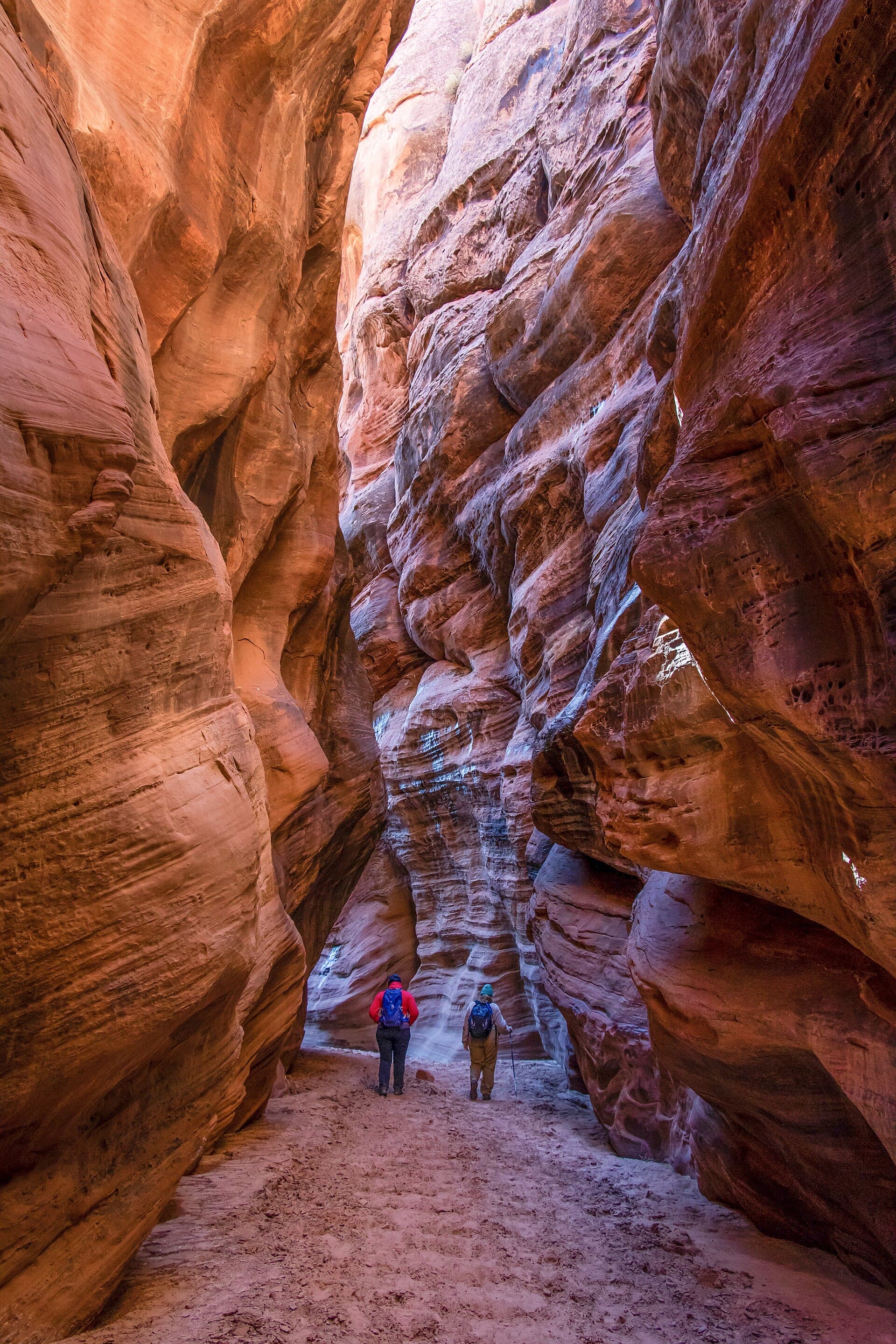
Paria Canyon is one of the most immersive slot canyon experiences anywhere - a point-to-point backpack from Utah to Arizona down the Paria River, through what BLM describes as a 2,500-foot-deep canyon whose narrows run only a few feet wide in places and several hundred feet deep.
The canyon demands constant river crossings. BLM says to expect to be in and out of the water continuously, over miles of cobbled streambed that make footing difficult, past boulder jams as tall as 20 feet, quicksand, deep mud, and pools cold and deep enough to require swimming.
Overnight entry is capped at 20 people a day, counted cumulatively across all four trailheads, so solitude comes standard. BLM does not limit the number of groups - only the head count, and group size, which tops out at 10.
Paria Canyon represents slot canyon wilderness at its most raw and expansive. The confluence with Buckskin Gulch creates the longest slot canyon system in the world—a geologic marvel that takes days, not hours, to traverse.
From White House Trailhead, the river immediately claims your feet as you enter the Paria Narrows. The walls grow steadily taller - BLM puts the canyon at 2,500 feet deep. Buckskin Gulch joins from the north, part of what Recreation.gov calls one of the longest slot canyon systems in the United States. Boulder jams, mud pits, and constant river crossings define the middle miles before the canyon opens near Big Water and Wrather Canyon. The final stretch to Lee's Ferry passes ancient petroglyphs and cottonwood groves as the Colorado River draws near.
The canyon walls climb higher with each mile until they block the sky itself, leaving only a ribbon of blue far above. You wade the Paria River dozens of times daily, the silty water swirling around your legs as ancient petroglyphs watch from alcoves. At night, the canyon amplifies every sound—the river's murmur becomes a symphony.
Primary starting point for the through-hike, most direct canyon access
Reached by a sand and gravel access road. BLM publishes no parking capacity for the trailhead.
Dirt road from Highway 89 between Page and Kanab. Passenger cars OK when dry.
Kanab (43 miles) or Page (30 miles from the Paria Contact Station) - full services
Exit point at Colorado River—historic ferry crossing site
Large parking area. Day use fee required.
Off Highway 89A near Marble Canyon, Arizona. Paved access.
Marble Canyon (5 miles) - gas station, store and post office. Page (42 miles) for full services
Required and recommended gear for Paria Canyon
Trailhead transportation options
Browse all shuttlesExperienced wilderness guides
Browse all guidesSome links may be affiliate links. Purchases support PermitSnag at no extra cost to you.
Paria Canyon permits use a reservation system. PermitSnag sends lottery open, deadline, and results reminders; you can also enable cancellation alerts if spots open later.
Check with the managing agency for current season dates. Weekdays generally have better availability than weekends.
This permit has a demand score of 8/10, making it highly competitive. We recommend having backup dates and using PermitSnag's cancellation alerts.
Cancellations happen daily. Set up alerts with PermitSnag to get notified the moment a spot opens up. Pro and $19 single-permit alerts are checked about every minute, 24/7; free accounts are checked hourly.
No active conditions reported
Sign in to report trail conditions.
No questions yet
Be the first to ask about Paria Canyon.
Midday offers the best light in slot canyons when sun beams penetrate to the canyon floor. The Narrows section around mile 5-7 catches light beams around noon.
Slot canyons are actually best photographed at midday for light shafts. Wider sections at camps photograph well at golden hour.
Overnight entry is capped at 20 people a day across all four trailheads, so the canyon stays quiet. BLM does not cap the number of groups, only the head count. Weekday starts see even fewer hikers.
Consider these alternatives if your preferred dates aren't available.
Day hike into Buckskin Gulch from Wire Pass. BLM measures 1.7 miles one-way to the Buckskin confluence and 13 miles one-way to the Paria confluence.
Day-use permit only ($6). Experiences the most dramatic slot canyon sections without multi-day commitment.
Add Buckskin Gulch to the traverse by starting at Wire Pass—significantly more technical.
Adds the most spectacular slot canyon scenery but also the most challenging obstacles including potential swimming.
Iconic sandstone formation in the same wilderness area—separate permit lottery.
Day hike only. Even more competitive permits. Different experience (formation vs canyon).
Nearby campgrounds to complete your Paria Canyon trip
A small favor
Google lets you pick the sites it highlights for you. Add PermitSnag and our permit pages get marked as one of yours in AI Overviews and AI Mode.
Takes less than a minute.